---
license: apache-2.0
task_categories:
- image-segmentation
- object-detection
- robotics
language:
- en
tags:
- robotics
- navigation
- frontiers
- autonomous-systems
- field-robotics
- vision-foundation-models
- outdoor-navigation
- traversability
- exploration
pretty_name: WildOS Frontiers Dataset
size_categories:
- n<1K
configs:
- config_name: default
data_files:
- split: train
path: "**"
---
# WildOS Frontiers Dataset
## Dataset Description
This dataset provides **visual frontier annotations** for outdoor long-range navigation, created for [WildOS: Open-Vocabulary Object Search in the Wild](https://leggedrobotics.github.io/wildos/). The annotations are built on top of images from the [GrandTour Dataset](https://huggingface.co/datasets/leggedrobotics/grand_tour_dataset).
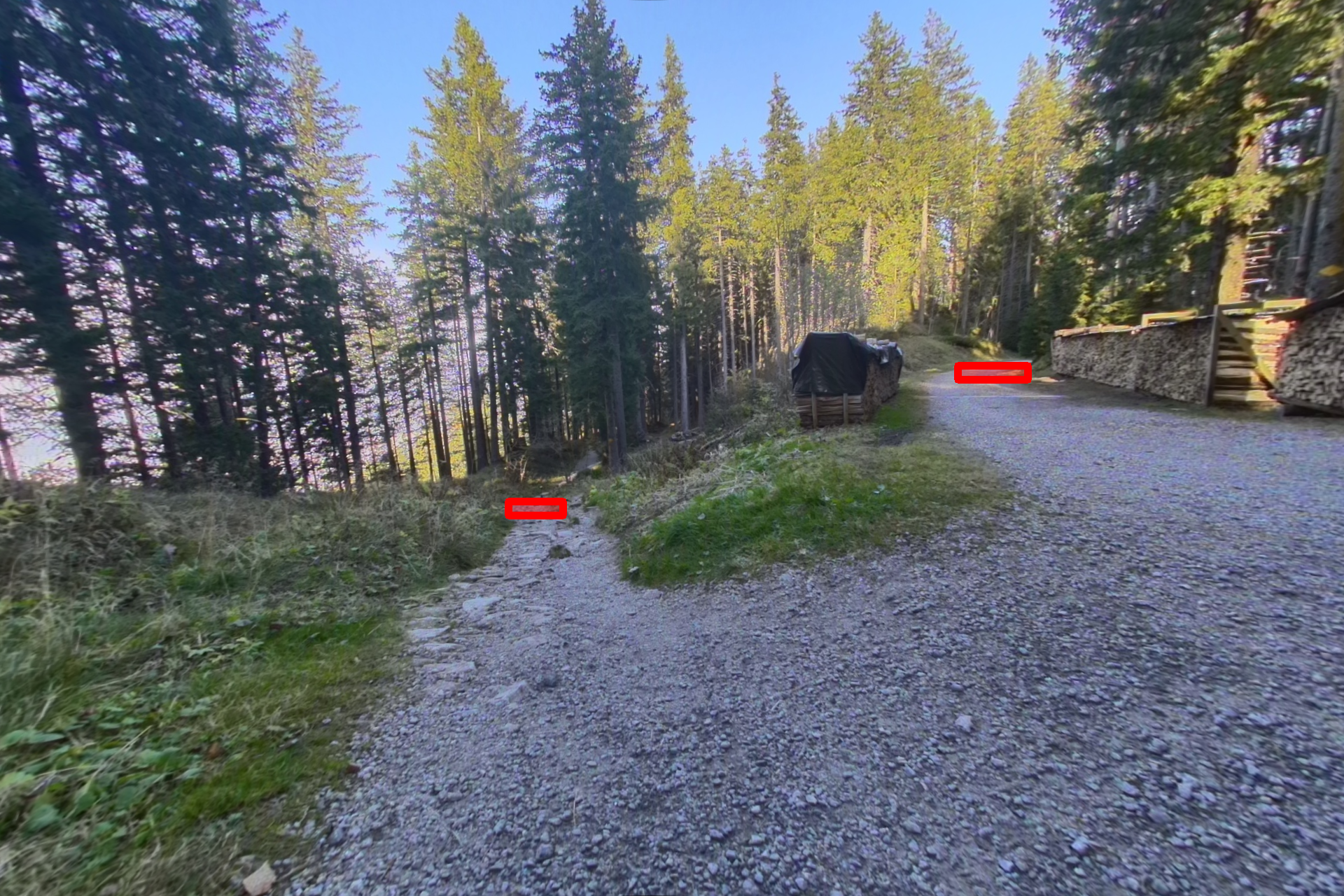
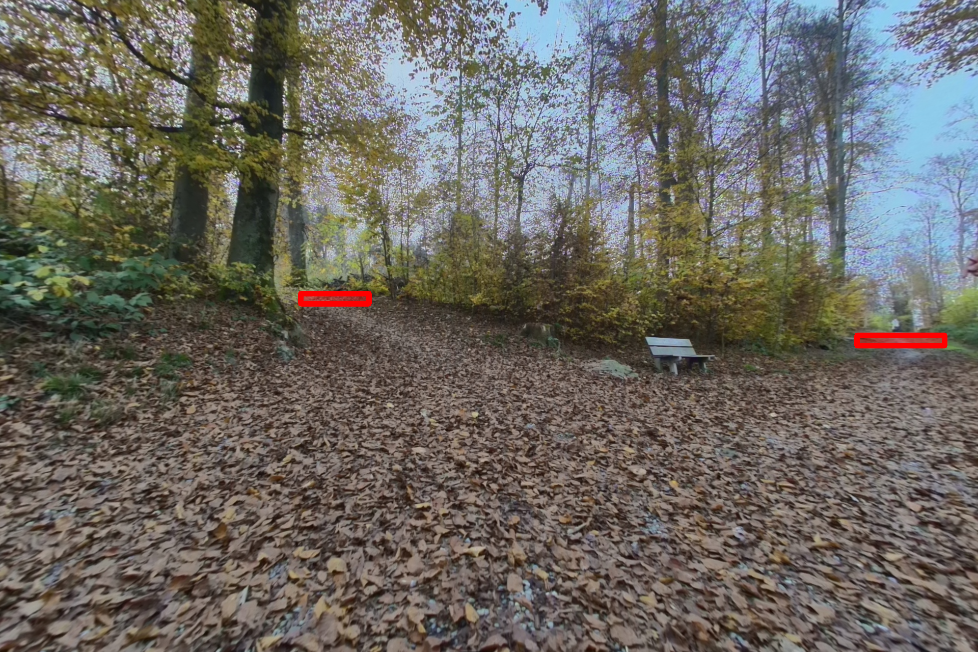
**Visual Frontiers** denote regions in the image that correspond to candidate locations for further exploration — such as the end of a trail, an opening
between trees, or a road turning at a curve. This dataset enables training of models to predict visual frontiers from RGB images, extending navigation reasoning beyond the geometric depth horizon.
## Dataset Structure
```
wildos/
├── annotations/ # Frontier annotations (362 JSON files)
│ └── annotation_00000.json ... annotation_00389.json
├── RGB_frames/ # Raw RGB frames (390 images + metadata)
│ ├── metadata.json # Maps to original GrandTour images
│ └── rgb_00000.png ... rgb_00389.png
├── RGB_rectified/ # Rectified RGB images (390 images)
│ └── rect_00000.png ... rect_00389.png
└── SAM_boundaries/ # SAM-2 boundary masks (390 images)
└── bound_00000.png ... bound_00389.png
```
### File Descriptions
| Folder | Description | Count |
|--------|-------------|-------|
| `annotations/` | JSON files containing frontier bounding box annotations | 362 |
| `RGB_frames/` | Original RGB frames from GrandTour dataset | 390 + 1 metadata |
| `RGB_rectified/` | Rectified (undistorted) RGB images | 390 |
| `SAM_boundaries/` | Binary masks from SAM-2 boundary detection | 390 |
> **Note:** Some images do not have corresponding annotations (362 out of 390 images are annotated). Images without annotations were excluded during quality control. The `SAM_boundaries/` folder contains SAM-2 boundary masks used in an ablation study, where frontiers were defined as the SAM boundary segments within human-annotated bounding boxes.
## Annotation Format
Each annotation file contains a list of frontier detections with the following structure:
```json
[
{
"label": "frontier",
"start": [1326.0, 618.0],
"end": [1352.0, 636.0]
}
]
```
| Field | Description |
|-------|-------------|
| `label` | Frontier label (currently `"frontier"` for all annotations) |
| `start` | Top-left corner `[x, y]` of the bounding box |
| `end` | Bottom-right corner `[x, y]` of the bounding box |
> **Note:** The `label` field exists because we initially experimented with labeling frontiers of varying strengths. In the final dataset, all annotations use the single label `"frontier"`.
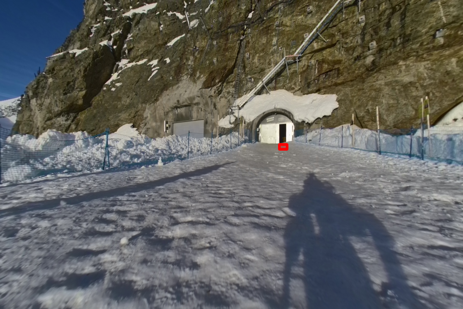
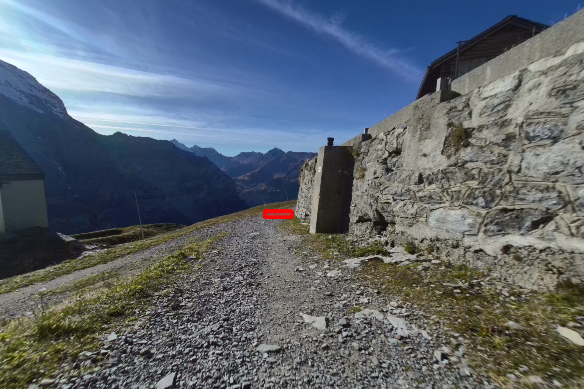
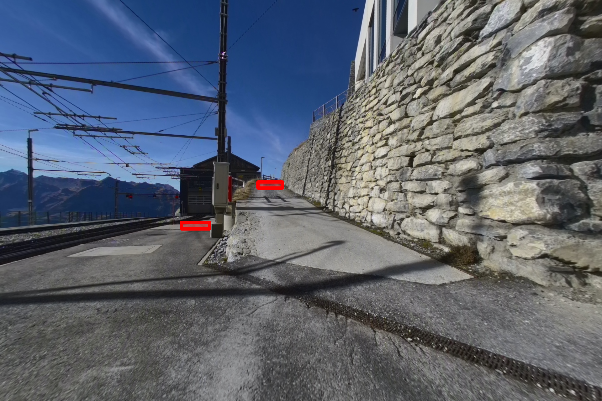
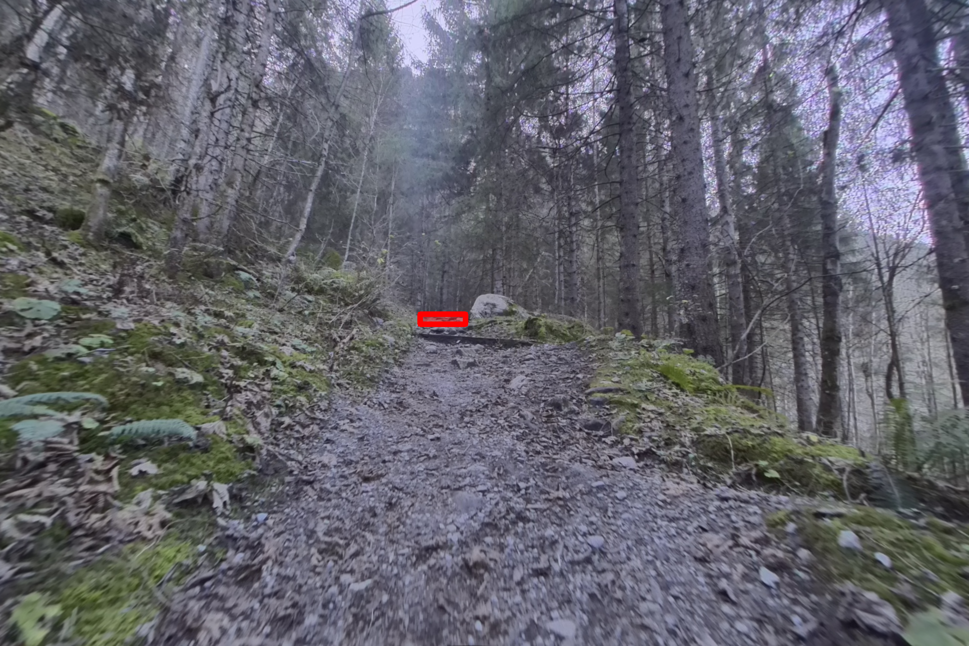
## Example Annotations
*Red regions indicate visual frontiers — candidate locations for further exploration.* More examples can be viewed [here](https://leggedrobotics.github.io/wildos/#frontier-annotations).
## Usage
### Loading Individual Files
```python
import json
from PIL import Image
# Load an annotation
with open("wildos/annotations/annotation_00000.json", "r") as f:
annotations = json.load(f)
# Load corresponding image
image = Image.open("wildos/RGB_rectified/rect_00000.png")
print(f"Image size: {image.size}")
print(f"Number of frontiers: {len(annotations)}")
```
### Visualizing Annotations
Visualize frontier annotations on images:
```python
import os
import json
import cv2
import numpy as np
def visualize_frontiers(image_path, annotation_path, output_path=None):
"""Draw frontier annotations on an image."""
# Load image
img = cv2.imread(image_path)
# Load annotations
with open(annotation_path, "r") as f:
annotations = json.load(f)
# Draw each frontier
for ann in annotations:
x1, y1 = int(ann["start"][0]), int(ann["start"][1])
x2, y2 = int(ann["end"][0]), int(ann["end"][1])
color = (0, 0, 255) # Red in BGR
# Draw semi-transparent rectangle
overlay = img.copy()
cv2.rectangle(overlay, (x1, y1), (x2, y2), color, -1)
cv2.addWeighted(overlay, 0.35, img, 0.65, 0, img)
cv2.rectangle(img, (x1, y1), (x2, y2), color, 2)
if output_path:
cv2.imwrite(output_path, img)
return img
# Example usage
visualize_frontiers(
"wildos/RGB_rectified/rect_00000.png",
"wildos/annotations/annotation_00000.json",
"output_visualization.png"
)
```
### Metadata Mapping
The `metadata.json` file in `RGB_frames/` maps each image index to its source path in the GrandTour dataset:
```python
import json
with open("wildos/RGB_frames/metadata.json", "r") as f:
metadata = json.load(f)
# Find original GrandTour image for a specific frame index
original_path = metadata["0"] # e.g., "release_2024-11-03-07-57-34/hdr_front/hdr_front_01342.png"
print(f"Original GrandTour path: {original_path}")
```
## Related Resources
- **Project Page**: [WildOS: Open-Vocabulary Object Search in the Wild](https://leggedrobotics.github.io/wildos/)
- **Source Dataset**: [GrandTour Dataset](https://huggingface.co/datasets/leggedrobotics/grand_tour_dataset)
## Citation
If you use this dataset in your research, please cite:
```bibtex
@misc{shah2026wildosopenvocabularyobjectsearch,
title={WildOS: Open-Vocabulary Object Search in the Wild},
author={Hardik Shah and Erica Tevere and Deegan Atha and Marcel Kaufmann and Shehryar Khattak and Manthan Patel and Marco Hutter and Jonas Frey and Patrick Spieler},
year={2026},
eprint={2602.19308},
archivePrefix={arXiv},
primaryClass={cs.RO},
url={https://arxiv.org/abs/2602.19308},
}
```
## License
This dataset is released under the [Apache 2.0 License](https://www.apache.org/licenses/LICENSE-2.0).