| --- |
| pretty_name: SEN2NEON (Validation) |
| license: cc-by-4.0 |
| tags: |
| - remote-sensing |
| - geospatial |
| - sentinel-2 |
| - super-resolution |
| - multispectral |
| - earth-observation |
| task_categories: |
| - image-to-image |
| task_ids: |
| - super-resolution |
| annotations_creators: |
| - no-annotation |
| language_creators: |
| - other |
| language: [] |
| multilinguality: |
| - other |
| size_categories: |
| - 1K<n<10K |
| dataset_info: |
| features: |
| - name: id |
| dtype: string |
| - name: lr |
| dtype: image |
| - name: hr |
| dtype: image |
| - name: split |
| dtype: string |
| - name: name |
| dtype: string |
| - name: lon |
| dtype: float64 |
| - name: lat |
| dtype: float64 |
| - name: LC_detail_id |
| dtype: int64 |
| - name: LC_detail_text |
| dtype: string |
| - name: LC_superclass_id |
| dtype: int64 |
| - name: LC_superclass_text |
| dtype: string |
| --- |
| |
| # SEN2NEON (Validation Subset) |
| LR/HR Multispectral Super‑Resolution Dataset for benchmarking and research. |
|  |
|
|
|
|
| --- |
|
|
| ## Dataset Summary |
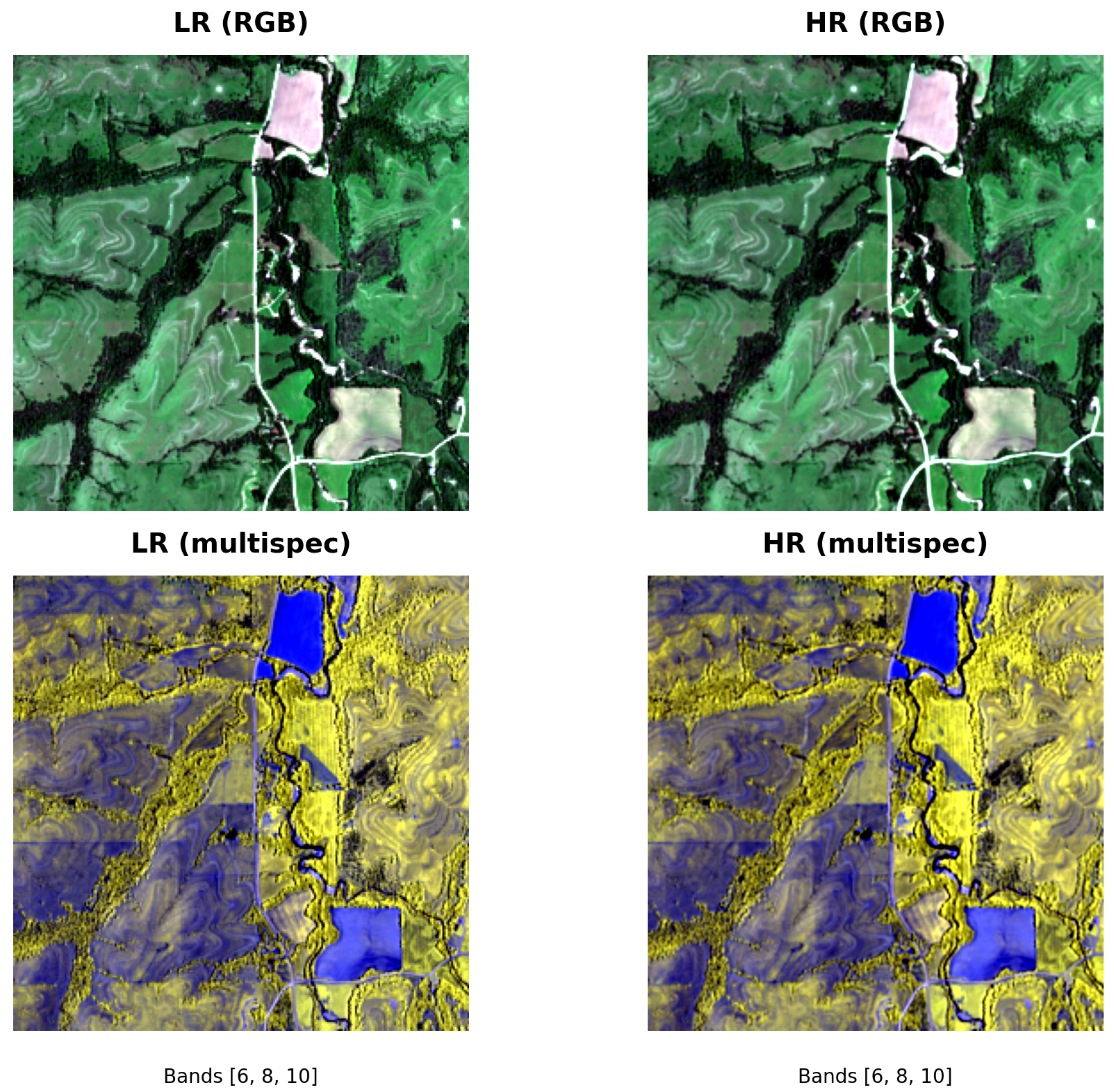
| SEN2NEON provides paired **low‑resolution (LR, 10 m)** and **high‑resolution (HR, 2.5 m)** GeoTIFF tiles for validating super‑resolution (SR) models in remote sensing. Each pair shares the same spatial footprint; HR is an integer 4× upsample of LR and is pixel‑aligned. A companion `metadata.jsonl`/CSV file supplies per‑tile metadata and land‑cover labels to enable **stratified evaluation** (e.g., Forest vs Built‑up). |
| The code, examples and validation workflowws can be found at [ESAOpenSR/SEN2NEON](https://github.com/ESAOpenSR/SEN2NEON). |
|
|
| - **Modality:** Multispectral GeoTIFFs (band count may vary by source preprocessing) |
| - **Tasks:** Super‑resolution (image‑to‑image), benchmarking & analysis |
| - **Scale:** ~30 GB total (varies by release) |
| - **Alignment:** HR is 4× LR; integer, isotropic scale; pixel‑aligned |
| - **Geo:** UTM/ETRS zones per tile (see `crs` in CSV); `lon/lat` provided for centroids |
|
|
| --- |
|
|
| ## Repository Layout |
| ``` |
| . |
| ├── metadata.jsonl # line‑delimited JSON index (recommended entry point) |
| ├── sen2neon_metadata.csv # CSV index (same content as JSONL, tabular form) |
| ├── neon_10m_linearized/ # LR tiles (GeoTIFF) |
| └── neon_2.5m_linearized/ # HR tiles (GeoTIFF) |
| ``` |
| Relative paths in the JSON/CSV (e.g., `neon_10m_linearized/…`) match the on‑hub layout. |
|
|
| --- |
|
|
| ## Record Schema (metadata.jsonl) |
| Each line is one sample: |
| ```json |
| { |
| "id": "<stem>", |
| "lr": "neon_10m_linearized/<file>.tif", |
| "hr": "neon_2.5m_linearized/<file>.tif", |
| "split": "val", |
| "name": "<filename.tif>", |
| "lon": <float or null>, |
| "lat": <float or null>, |
| "LC_detail_id": <int or null>, |
| "LC_detail_text": "<str or null>", |
| "LC_superclass_id": <int or null>, |
| "LC_superclass_text": "<str or null>" |
| } |
| ``` |
| Notes: |
| - `split` is set to `"val"` for this release. |
| - `lon/lat` are WGS84 centroids; may be null for tiles outside coverage. |
| - LC fields come from the categorical land‑cover raster used in preprocessing (see below). |
|
|
| --- |
|
|
| ## Quick Download |
| Using the Hub snapshot cache (resumable, selective patterns): |
| ```bash |
| pip install -U huggingface_hub |
| python - <<'PY' |
| from huggingface_hub import snapshot_download |
| snapshot_download( |
| repo_id="simon-donike/SEN2NEON", |
| repo_type="dataset", |
| local_dir="./data/sen2neon", |
| allow_patterns=[ |
| "metadata.jsonl", |
| "sen2neon_metadata.csv", |
| "neon_10m_linearized/**", |
| "neon_2.5m_linearized/**" |
| ], |
| ) |
| PY |
| ``` |
|
|
| (For high‑throughput, you can `pip install hf_transfer` and set `HF_HUB_ENABLE_HF_TRANSFER=1`.) |
|
|
| --- |
|
|
| ## Load with 🤗 Datasets (Streaming, no full download) |
| ```python |
| from datasets import load_dataset, Image |
| |
| # Stream JSONL, keep paths relative to the Hub |
| ds = load_dataset( |
| "json", |
| data_files="hf://datasets/simon-donike/SEN2NEON/metadata.jsonl", |
| split="train", # streaming uses a single split; filter by 'split' field if needed |
| streaming=True |
| ) |
| |
| # Cast path fields to Image feature to lazily fetch TIFFs |
| ds = ds.cast_column("lr", Image()) |
| ds = ds.cast_column("hr", Image()) |
| |
| row = next(iter(ds)) |
| lr_img = row["lr"] # dict with 'path' and PIL image accessor |
| hr_img = row["hr"] |
| print(row["id"], row.get("LC_superclass_text")) |
| ``` |
|
|
| --- |
|
|
| ## Load with PyTorch (Local Files) |
| After downloading (e.g., into `./data/sen2neon/`), you can use the provided CSV‑driven loader: |
| ```python |
| from data.sen2neon_ds import SEN2NEON |
| from torch.utils.data import DataLoader |
| |
| root = "./data/sen2neon" |
| csv = f"{root}/sen2neon_metadata.csv" |
| |
| ds = SEN2NEON(csv_path=csv, root_dir=root, crop_size_lr=None) |
| loader = DataLoader(ds, batch_size=2, shuffle=True, num_workers=4, pin_memory=True) |
| |
| batch = next(iter(loader)) |
| lr, hr, meta = batch["lr"], batch["hr"], batch["meta"] |
| print(lr.shape, hr.shape, meta["LC_superclass_text"][:2]) |
| ``` |
|
|
| --- |
|
|
| ## Land‑cover Integration |
| Each sample is joined with **land‑cover** information derived from an external categorical land‑cover raster covering the study area. The LR tile footprint is reprojected to the LC CRS; the **mode** value within that window is taken as the label. |
| - `LC_detail_id` / `LC_detail_text`: fine‑grained class (e.g., 41 → “Deciduous”). |
| - `LC_superclass_id` / `LC_superclass_text`: coarser **super‑group** (e.g., 40 → “Forest”, 50 → “Built‑up”). |
| - These fields enable **stratified metrics** (e.g., PSNR/SSIM/SAM) by environment type. |
| - Missing values may occur (outside coverage / NoData). |
|
|
| --- |
|
|
| ## Geospatial & Data Notes |
| - **CRS:** Tiles are stored in per‑scene/projected UTM/ETRS zones; see `crs` in the CSV (when available). Centroids are additionally provided as WGS84 (`lon/lat`). |
| - **Alignment:** HR is an exact 4× integer scaling of LR with pixel‑grid alignment. |
| - **Nodata:** TIFF `nodata` values are respected; downstream loaders may map them to NaN. |
| - **Bands:** Band count may vary across scenes; code examples select RGB if available (else fallbacks). |
|
|
| --- |
|
|
| ## Intended Uses |
| - Benchmarking SR models (classical, CNN, diffusion, GANs). |
| - Stratified evaluation by land‑cover class (robust performance reporting). |
| - Qualitative visualization and error analysis. |
|
|
| ## Limitations |
| - Land‑cover labels are window‑mode summaries, not per‑pixel annotations. |
| - Some tiles may lack LC labels or have ambiguous boundaries near class transitions. |
| - Sensor mix / preprocessing differences can affect cross‑domain generalization. |
|
|
| --- |
|
|
| ## License |
| Please refer to the dataset repository license on the Hub page. If you fork/modify, include the original attribution. (Contact the maintainers for commercial/redistribution questions.) |
|
|
| --- |
|
|
| ## Citation |
| If you use SEN2NEON in your research, please cite the dataset and the accompanying tools. A publication is in the works. |
|
|
| --- |
|
|
| ## Contact |
| - Maintainer: Image Processing Laboratory, University of Valencia, Spain |
| - Issues & questions: open a discussion on the linked GitHub repository. |
|
|

