Datasets:

Alto Valle Dataset
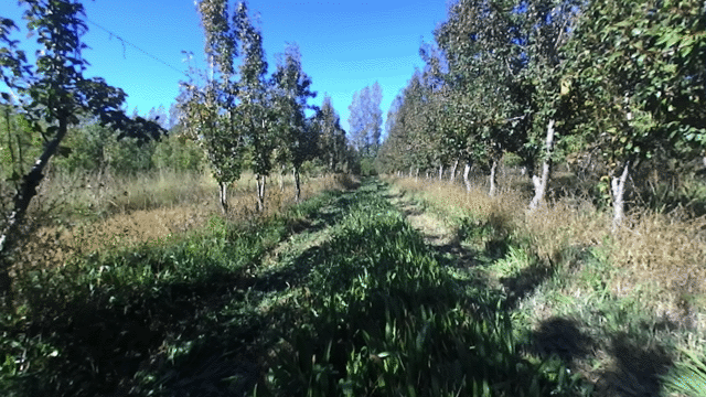
Autonomous navigation data in Alto Valle Pear Orchards
📖 Overview
The Alto Valle Dataset is a collection of experimental data acquired in pear orchards (Pyrus communis) at the INTA Alto Valle Experimental Station (Río Negro, Argentina).
The main goal of this dataset is to support the development of localization, mapping (SLAM), and navigation algorithms in agricultural environments. It presents unique challenges such as:
- High variability in lighting and terrain.
- Seasonal changes: Data captures during Summer/Autumn (leafy, pre-harvest) and Winter (leafless, pruning).
- Repetitive structures (rows of trees).
🚜 Hardware & Setup
The data was captured using a modified N. Blosi Senior harvesting platform moving at approximately $0.3 m/s$.
| Sensor Type | Model | Specifications |
|---|---|---|
| Stereo Camera | Stereolabs ZED | 720x1280 @ 15 FPS. USB 3.0 connected to Nvidia Jetson TX1. |
| LiDAR | SICK LMS-100 | 2D LiDAR, 50Hz (stored at 1Hz), 270° FOV, 0.5° resolution. |
| GNSS-RTK | U-BLOX C94-M8P-2 | Base + Rover setup (915MHz link). ~2.5cm accuracy. 1Hz update rate. |
The sensors were mounted 2.5m high, with the camera acting as the reference frame.
📁 Dataset Structure
The dataset is organized by sequences (April and August). Each sequence contains:
dataset/
├── sequenceXX/
│   ├── images/
│   │   ├── left_<index>.png    # Rectified left image
│   │   ├── right_<index>.png   # Rectified right image
│   │   └── timestamps.txt      # Image timestamps
│   ├── lidar.csv               # LiDAR readings
│   └── gnss.csv                # GNSS-RTK readings
Data Format Details
- Images: PNG format, rectified.
- GNSS (
gnss.csv): Format:[latitude | longitude | timestamp] - LiDAR (
lidar.csv): Format:[timestamp | nscan | 541 x range]nscan: Frame number generated by the sensor.range: 541 distance values (0.5° angular resolution).
📐 Calibration Parameters
Intrinsic parameters for the ZED Camera used in this dataset. The baseline is 120.647 mm.
| Parameter | Left Camera | Right Camera |
|---|---|---|
| fx | 692.964 | 698.848 |
| fy | 692.964 | 698.848 |
| cx | 576.186 | 737.995 |
| cy | 367.798 | 361.795 |
| k1 | -0.182798 | -0.1634 |
| k2 | 0.0277213 | 0.0214219 |
Extrinsic parameters (transformations between sensors) are available in the PDF documentation or the paper.
📅 Seasons & Conditions
The dataset covers different phenological stages of the pear crops (Williams, Abate Fetel, and Beurré D’Anjou varieties):
- April 09, 2018 (Autumn):
- Condition: Pre-harvest. Dense foliage, branches weighed down by fruit.
- Weather: Sunny, variable lighting (shadows/direct sun).
- Ground: Presence of weeds, irrigation ditches.
- August 06, 2018 (Winter):
- Condition: Pruning season. Deciduous trees (no leaves). Visible trunks and structure.
- Weather: Partly cloudy/overcast.
- Ground: Cleared weeds.
📥 Access & Download
The data is split into .tar archives due to size. You can download them directly from the Files and versions tab.
⚖️ Legal Notice & Citation
The content of this database is under Copyright of the Universidad Nacional del Comahue and INTA EEAV.
If you use this dataset in your research, please cite the work presented at Jornadas Argentinas de Robótica (JAR) 2022:
- Paper: Read PDF (Spanish)
- Video: Watch on YouTube
@inproceedings{alto_valle_dataset_2022,
  title={Alto Valle Dataset: colección de datos experimentales enfocados en el estudio y desarrollo de algoritmos de navegación mediante visión en ambientes frutícolas},
  author={Sansoni, Sebastian and Raverta Capua, Francisco and Moreyra, Marcelo L. and Benitez Piccini, Edgardo},
  booktitle={Jornadas Argentinas de Robótica (JAR)},
  year={2022},
  organization={Universidad Nacional del Comahue & INTA EEAV},
  url={https://github.com/Seba-san/AltoValleDataset}
}
Acknowledgments
This work was supported by the Project of Social Technological Development (PDTS) "Sistemas de Asistencia al Productor y Automatización de Máquinas para la Fruticultura de la Norpatagonia" (PDTS404), funded by CIN and CONICET.
- Downloads last month
- 31